Asia · Independently researched guide
Karakol outdoor guide
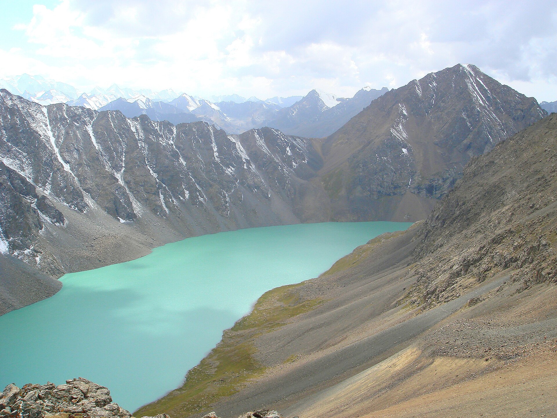
The eastern Issyk-Kul gateway for Ala-Kul trekking, Tien Shan horse routes, backcountry skiing, climbing and hot-spring itineraries.
Quick answer
What is Karakol best for?
Karakol is best for high-altitude trekking, horse trekking, backcountry skiing, mountaineering, hot-spring routes. The most useful areas to research first are Ala-Kul Pass loop, Altyn Arashan, Karakol and Ak-Suu gorges, Jyrgalan Valley.
Conditions at a glance
Weather, elevation and waves
Planning context is separated from live conditions so the numbers are useful without pretending to be a forecast.
Typical weather
3–13°C
Across the months listed in this guide, 2021–2025 daily averages were about 3–13°C, with 65 mm of precipitation in an average listed month.
Base elevation
1,752 m
1,752 m at the city-base model grid point. Route and summit elevations can be substantially different.
Waves, rivers or route terrain
4 named route areas
No general wave-height claim is shown. This guide focuses on Ala-Kul Pass loop, Altyn Arashan, Karakol and Ak-Suu gorges and other route areas.
Interactive month planner
How conditions change through the year
Select a month to compare typical air temperature, precipitation, base elevation context and the broad outdoor planning window.
Typical weather
Choose a month
Base elevation
1,752 m
Route planning
Choose a month
View the complete 12-month dataset
| Month | Typical low–high | Average precipitation | Outdoor planning fit |
|---|---|---|---|
| January | -10–-2°C | 27 mm | Preferred outdoor window |
| February | -9–0°C | 32 mm | Preferred outdoor window |
| March | -4–6°C | 65 mm | Preferred outdoor window |
| April | 1–13°C | 86 mm | Outside broad preferred window |
| May | 6–17°C | 130 mm | Outside broad preferred window |
| June | 10–20°C | 96 mm | Preferred outdoor window |
| July | 13–23°C | 72 mm | Preferred outdoor window |
| August | 11–22°C | 67 mm | Preferred outdoor window |
| September | 8–19°C | 99 mm | Preferred outdoor window |
| October | 1–12°C | 77 mm | Outside broad preferred window |
| November | -4–4°C | 51 mm | Outside broad preferred window |
| December | -8–-1°C | 41 mm | Outside broad preferred window |
Historical monthly averages describe seasonal potential, not the conditions on a specific travel day. Use the named route notes with a current local forecast, closure notice and activity-specific conditions report.
Cost and connectivity
What housing and remote work may cost
The cost bars preserve the practical comparison from the original guide. Internet figures now use area-level fixed-network observations instead of an unsupported property-speed claim.
Monthly planning model
US$1,500 total
Broad editorial planning estimate. It is not a live quote and does not include flights, visas, insurance or major equipment purchases.
Area fixed-network signal · 2026 Q1
81.8 Mbps download
Test-weighted Ookla map-tile average within approximately 10 km of the destination coordinates. This describes the surrounding fixed network—not the Wi-Fi quality of a particular room or coworking space.
Nightly accommodation planning ranges
Compare stay types
Private rental
US$36–56/nightHotel room
US$72–102/nightHostel dorm
US$12–20/nightThese are expanded planning ranges from Nuevo Adventure's existing lodging model, not scraped Airbnb or live hotel inventory. Season, taxes, room type, location and booking lead time can materially change the total. Verify against live dates before booking.
Area-by-area guide
Best outdoor areas and route options
These are distinct areas, not interchangeable recommendations. Read the suitability note for each and verify current conditions before committing.
High-altitude trekking
Ala-Kul Pass loop
The signature route crosses a roughly 3,900 m pass; snow, scree, weather and acclimatization make it a serious multi-day objective.
Locate this areaTrekking and hot springs
Altyn Arashan
The valley combines trekking with hot-spring stays, but its rough access road is not appropriate for ordinary cars.
Locate this areaTrekking and mountaineering
Karakol and Ak-Suu gorges
Multiple valleys lead into remote alpine terrain with river crossings, limited signage and route-specific permit considerations.
Locate this areaBackcountry skiing and horse trekking
Jyrgalan Valley
Seasonal routes need local access, avalanche and horse-welfare checks rather than a generic destination forecast.
Locate this areaIs it your kind of trip?
Would you enjoy using Karakol as your base?
Karakol is a staging town for serious Tien Shan trips rather than a trailhead you casually walk from after breakfast. Ala-Kul, Altyn Arashan and multi-pass traverses involve transfers, camping or yurt logistics, high altitude and abrupt weather.
high-altitude trekking and horse trekking are why you are here
The eastern Issyk-Kul gateway for Ala-Kul trekking, Tien Shan horse routes, backcountry skiing, climbing and hot-spring itineraries. Ala-Kul Pass loop is a logical first area to research; it is not a promise of beginner terrain, so confirm the exact route or session locally.
You want every day to be predictable
The clearest example is Jyrgalan Valley: Seasonal routes need local access, avalanche and horse-welfare checks rather than a generic destination forecast. That does not make the trip a bad idea; it means acclimatize, carry navigation and emergency communication, and verify border-zone permits where applicable. Winter travel requires avalanche training, rescue gear and current local guidance.
Expect transfers and a few early starts
Karakol is the single city base for supplies, guides and transport. Ala-Kul and Altyn Arashan are backcountry routes; Jyrgalan is a separate valley excursion. Day to day, you will be relying on Marshrutka, taxi, 4WD transfer & horse support. Check the first and last connection before committing to an early start.
July; heat, sun and afternoon weather may change start times.
January; pack for inactive periods and higher terrain, not only the town forecast.
May; precipitation can affect trails, access roads, river flow and visibility differently.
June, July, August, September, January, February, March. This combines several sports, so choose the month in the planner for activity-specific context.
Picture the stay
What 3 days, 1 week or a month in Karakol could look like
Karakol is really two different trips: a snow-season base and a summer mountain base. Choose that version first, then check lift, hut, road and guide schedules for the exact week. Think of these as useful shapes for a trip, not reservations you have to force when conditions change.
Use three days for one short route
- Spend arrival day arranging transport, food, weather information and equipment; a town or Jeti-Oguz outing is more sensible than rushing directly toward a high pass.
- A three-day Ala-Kul itinerary is already a committed route. Use a qualified local plan, acclimatize and expect the pass to reach roughly 3,900 metres.
- Protect the final descent and return transfer rather than adding another valley. Steep scree and large elevation loss can be harder than the summit photograph suggests.
Ala-Kul becomes a journey, not a sprint
A week allows an Ak-Suu or Karakol Gorge approach, Ala-Kul, Altyn Arashan and recovery without pretending every group moves at guidebook pace. Arrange camping, meals, porter choices and transport before departure.
Base in town between mountain blocks
Use Karakol for resupply, work and recovery between guided or self-sufficient trekking blocks. Internet at remote camps cannot be assumed even when an operator advertises it. June through September is a broad trekking window, not a pass guarantee.
Remote-work reality
Where to base yourself
Karakol is the single city base for supplies, guides and transport. Ala-Kul and Altyn Arashan are backcountry routes; Jyrgalan is a separate valley excursion.
We do not label a destination's Wi-Fi as “tested” without property-level evidence. Ask a host for a recent speed test, confirm mobile coverage and keep a backup connection.
Safety and access
What can change the plan
Acclimatize, carry navigation and emergency communication, and verify border-zone permits where applicable. Winter travel requires avalanche training, rescue gear and current local guidance.
Forecasts, permits, closures and operator standards change. This guide is planning context, not a substitute for current official advice or professional instruction.
Before paying an operator
What to verify before booking in Karakol
Send the operator the names Ala-Kul Pass loop, Altyn Arashan, Karakol and Ak-Suu gorges, Jyrgalan Valley and ask which one the booking actually uses. A product title can describe a region without guaranteeing the route, break, river section or launch you expect.
Hiking and mountain routes
- Match the exact route, elevation gain, surface and turnaround time to the slowest person.
- Check permits, closures, water availability, daylight and the current local forecast.
- Download an offline route and identify who coordinates rescue; phone signal is not an emergency plan.
Snow and alpine terrain
- Check lift, road and hut operating dates separately from broad “ski season” marketing.
- Use the current avalanche bulletin and route-specific hazard advice; a resort forecast is not a backcountry assessment.
- Confirm guide scope, transceiver/shovel/probe provision and rescue insurance for the exact terrain.
Useful proof to keep: the exact meeting point, inclusions, participant requirements, operator reply, cancellation terms and emergency contact. Recheck conditions close to departure.
Map location
Where Karakol sits
Karakol, Kyrgyzstan · 42.4900, 78.3900. Use the map as orientation, then open the named activity areas above for route-specific planning.
Optional external content
Load the interactive map
OpenStreetMap receives technical connection data, such as your IP address, only after you choose to load this map.
Plan the experience
Book classes and guided activities in Karakol
These are individual Viator experiences whose activity and operating location match this guide, with hiking tour prioritized. Confirm the meeting point, ability level, inclusions and cancellation terms before booking.
Commission disclosure: Nuevo Adventure may earn a commission if you book or buy through these links, at no extra cost to you. Partner payments do not change the editorial guidance on this page.
 Viator listing
2-Day Private Express: Issyk Kul Nomadic- Karakol Ski Adventure
Experience the ultimate Kyrgyz winter contrast in just 48 hours. This private expedition takes you from the ancient Silk Road ruins of Burana Tower to the world-class slopes of the Karakol…
Viator listing
2-Day Private Express: Issyk Kul Nomadic- Karakol Ski Adventure
Experience the ultimate Kyrgyz winter contrast in just 48 hours. This private expedition takes you from the ancient Silk Road ruins of Burana Tower to the world-class slopes of the Karakol…
 Viator listing
Trekking to Ala Kul Lake - Best of Tian Shan Mountains
No words to explain feelings…Get this memorable trekking experience with the magnificent scenery of alpine lake Ala Kul one of the most picturesque lakes of Central Asia. Enjoy the panorami…
Viator listing
Trekking to Ala Kul Lake - Best of Tian Shan Mountains
No words to explain feelings…Get this memorable trekking experience with the magnificent scenery of alpine lake Ala Kul one of the most picturesque lakes of Central Asia. Enjoy the panorami…
Direct answers
Karakol outdoor travel questions
What is Karakol best for outdoors?
Karakol is strongest for high-altitude trekking, horse trekking, backcountry skiing, mountaineering, hot-spring routes. The eastern Issyk-Kul gateway for Ala-Kul trekking, Tien Shan horse routes, backcountry skiing, climbing and hot-spring itineraries.
What are the best outdoor areas around Karakol?
Start with Ala-Kul Pass loop, Altyn Arashan, Karakol and Ak-Suu gorges, Jyrgalan Valley. The signature route crosses a roughly 3,900 m pass; snow, scree, weather and acclimatization make it a serious multi-day objective.
Is Karakol suitable for beginners?
Some guided or lower-commitment options may suit beginners, but the best-known terrain is not automatically beginner-friendly. Choose a qualified local provider and confirm current conditions.
When should I visit Karakol for outdoor activities?
The broad planning window in this guide is June, July, August, September, January, February, March. That combines the destination's main activities; the ideal month for one sport may be poor for another, so check the activity-specific forecast and operating calendar.
Can I work remotely from Karakol?
Karakol is the single city base for supplies, guides and transport. Ala-Kul and Altyn Arashan are backcountry routes; Jyrgalan is a separate valley excursion. Connection speed varies by building and provider, so request a recent speed test and confirm backup power or mobile coverage before booking a work-critical stay.
What weather and elevation should I plan for in Karakol?
Across the months listed in this guide, 2021–2025 daily averages were about 3–13°C, with 65 mm of precipitation in an average listed month. The base elevation is 1,752 m at the city-base model grid point. Route and summit elevations can be substantially different.
Provenance
Sources and image license
How this guide was researched: Desk-researched from Visit Kyrgyzstan’s current Ala-Kul and Ak-Suu itineraries, including published pass heights, seasons and route durations. Weather, trail and border conditions require local confirmation. Read the full editorial method.
- Location and map reference: OpenStreetMap contributors.
- Destination identity: Q194452 on Wikidata and Karakol on Wikipedia. These identity links disambiguate the place; they are not used as evidence for current conditions.
- Recent weather averages and model base elevation: Open-Meteo Historical Weather API, using daily data from 2021–2025. These are planning averages, not a live forecast.
- Area fixed-network download, upload and latency observations: Speedtest by Ookla Global Fixed and Mobile Network Performance Maps, 2026 Q1. Nuevo Adventure calculated a test-weighted average from map tiles within approximately 10 km of the destination coordinates; this is not a property Wi-Fi guarantee.
- Speedtest by Ookla Global Fixed and Mobile Network Performance Maps was accessed on 4 August 2026 from https://registry.opendata.aws/speedtest-global-performance/. Based on analysis by Ookla of Speedtest Intelligence data for 2026 Q1. Provided by Ookla and accessed 4 August 2026. Ookla trademarks used under license and reprinted with permission.
- Destination and activity guidance: Visit Kyrgyzstan: Ak-Suu Traverse to Ala-Kul. Route status, permits and operating information can change.
- Destination and activity guidance: Visit Kyrgyzstan tours from Karakol. Route status, permits and operating information can change.
- Bookable activity details, review totals, prices and availability links are supplied by Viator's partner catalog and can change after publication. Nuevo Adventure may earn a commission from qualifying bookings.
- Hero image: Ondřej Žváček, licensed under CC BY 2.5. The local copy was resized and compressed for web delivery; its license and credit travel with the record.
- Editorial review date: . Conditions and prices should be rechecked before travel.
Compare