North America · Independently researched guide
Sedona outdoor guide
A red-rock trail center with dense hiking and technical mountain biking close to town, constrained by heat and trailhead congestion.
Quick answer
What is Sedona best for?
Sedona is best for hiking, mountain biking, rock scenery. The most useful areas to research first are Cathedral Rock, Devil's Bridge, West Fork of Oak Creek, Hiline and Hangover.
Conditions at a glance
Weather, elevation and waves
Planning context is separated from live conditions so the numbers are useful without pretending to be a forecast.
Typical weather
7–21°C
Across the months listed in this guide, 2021–2025 daily averages were about 7–21°C, with 32 mm of precipitation in an average listed month.
Base elevation
1,322 m
1,322 m at the city-base model grid point. Route and summit elevations can be substantially different.
Waves, rivers or route terrain
4 named route areas
No general wave-height claim is shown. This guide focuses on Cathedral Rock, Devil's Bridge, West Fork of Oak Creek and other route areas.
Interactive month planner
How conditions change through the year
Select a month to compare typical air temperature, precipitation, base elevation context and the broad outdoor planning window.
Typical weather
Choose a month
Base elevation
1,322 m
Route planning
Choose a month
View the complete 12-month dataset
| Month | Typical low–high | Average precipitation | Outdoor planning fit |
|---|---|---|---|
| January | -1–10°C | 60 mm | Outside broad preferred window |
| February | 0–13°C | 42 mm | Outside broad preferred window |
| March | 2–15°C | 72 mm | Preferred outdoor window |
| April | 7–23°C | 15 mm | Preferred outdoor window |
| May | 12–27°C | 6 mm | Preferred outdoor window |
| June | 18–33°C | 10 mm | Outside broad preferred window |
| July | 21–35°C | 28 mm | Outside broad preferred window |
| August | 19–33°C | 42 mm | Outside broad preferred window |
| September | 16–30°C | 31 mm | Outside broad preferred window |
| October | 9–23°C | 40 mm | Preferred outdoor window |
| November | 4–17°C | 28 mm | Preferred outdoor window |
| December | 2–13°C | 36 mm | Outside broad preferred window |
Historical monthly averages describe seasonal potential, not the conditions on a specific travel day. Use the named route notes with a current local forecast, closure notice and activity-specific conditions report.
Cost and connectivity
What housing and remote work may cost
The cost bars preserve the practical comparison from the original guide. Internet figures now use area-level fixed-network observations instead of an unsupported property-speed claim.
Monthly planning model
US$3,100 total
Broad editorial planning estimate. It is not a live quote and does not include flights, visas, insurance or major equipment purchases.
Area fixed-network signal · 2026 Q1
240.7 Mbps download
Test-weighted Ookla map-tile average within approximately 10 km of the destination coordinates. This describes the surrounding fixed network—not the Wi-Fi quality of a particular room or coworking space.
Nightly accommodation planning ranges
Compare stay types
Private rental
US$100–156/nightHotel room
US$162–228/nightHostel dorm
US$36–59/nightThese are expanded planning ranges from Nuevo Adventure's existing lodging model, not scraped Airbnb or live hotel inventory. Season, taxes, room type, location and booking lead time can materially change the total. Verify against live dates before booking.
Area-by-area guide
Best outdoor areas and route options
These are distinct areas, not interchangeable recommendations. Read the suitability note for each and verify current conditions before committing.
Hiking
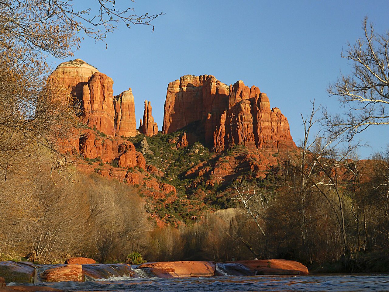
Cathedral Rock
A short but steep slickrock scramble with exposed-feeling sections and limited shade.
Locate this areaHiking
Devil's Bridge
A heavily visited natural-arch route whose access and shuttle arrangements vary by season.
Locate this areaHiking
West Fork of Oak Creek
A shaded canyon walk with repeated creek crossings and seasonal parking pressure.
Locate this areaMountain biking
Hiline and Hangover
Two renowned expert trails with exposure, ledges and consequential features rather than casual scenic riding.
Locate this areaIs it your kind of trip?
Would you enjoy using Sedona as your base?
Sedona makes the most sense when hiking and mountain biking are the reason you are coming. Here is what tends to feel great, what can become frustrating, and what everyday logistics are actually like.
hiking and mountain biking are why you are here
A red-rock trail center with dense hiking and technical mountain biking close to town, constrained by heat and trailhead congestion. Cathedral Rock is a logical first area to research; it is not a promise of beginner terrain, so confirm the exact route or session locally.
You want every day to be predictable
The clearest example is Cathedral Rock: A short but steep slickrock scramble with exposed-feeling sections and limited shade. That does not make the trip a bad idea; it means start early in hot weather, carry ample water and avoid exposed washes or slickrock during lightning and flash-flood risk.
Expect transfers and a few early starts
West Sedona is practical for services and several trailheads. The shuttle can be more efficient than searching for parking. Day to day, you will be relying on Rental Car. Check the first and last connection before committing to an early start.
July; heat, sun and afternoon weather may change start times.
January; pack for inactive periods and higher terrain, not only the town forecast.
March; precipitation can affect trails, access roads, river flow and visibility differently.
March, April, May, October, November. This combines several sports, so choose the month in the planner for activity-specific context.
Picture the stay
What 3 days, 1 week or a month in Sedona could look like
Sedona's broad season helps with the first decision, but route access and daily weather still matter more than forcing the same plan into every month. Think of these as useful shapes for a trip, not reservations you have to force when conditions change.
A simple first visit
- Start at Cathedral Rock. It gives you a useful first read on access, local conditions and whether the terrain feels like the trip you expected.
- Give the strongest forecast to Devil's Bridge. Check the route, elevation, water and turnaround details locally instead of choosing only by reputation.
- Keep the final day for West Fork of Oak Creek and Hiline and Hangover, recovery, or the plan displaced by weather. A flexible third day is usually more valuable than a third prepaid commitment.
Let the conditions choose the order
West Sedona is practical for services and several trailheads. The shuttle can be more efficient than searching for parking. Spend the week between Cathedral Rock, Devil's Bridge, West Fork of Oak Creek, and Hiline and Hangover, but keep one recovery or work day and one weather-flex day. Sedona's broad season helps with the first decision, but route access and daily weather still matter more than forcing the same plan into every month.
Build a routine before filling the calendar
A month gives you time to repeat hiking without chasing conditions every day. West Sedona is practical for services and several trailheads. The shuttle can be more efficient than searching for parking. Use the first week to test the trip to your priority area, gear storage, mobile backup and early-start transport. A broad working range is US$2,500–$3,900 before flights, insurance and major gear.
Remote-work reality
Where to base yourself
West Sedona is practical for services and several trailheads. The shuttle can be more efficient than searching for parking.
We do not label a destination's Wi-Fi as “tested” without property-level evidence. Ask a host for a recent speed test, confirm mobile coverage and keep a backup connection.
Safety and access
What can change the plan
Start early in hot weather, carry ample water and avoid exposed washes or slickrock during lightning and flash-flood risk.
Forecasts, permits, closures and operator standards change. This guide is planning context, not a substitute for current official advice or professional instruction.
Before paying an operator
What to verify before booking in Sedona
Send the operator the names Cathedral Rock, Devil's Bridge, West Fork of Oak Creek, Hiline and Hangover and ask which one the booking actually uses. A product title can describe a region without guaranteeing the route, break, river section or launch you expect.
Rafting, paddling and canyon water
- Get the exact river reach, current commercial grade and the flow or release threshold used to operate.
- Confirm minimum age, swim requirement, guide-to-guest ratio, PFD, helmet and thermal protection.
- Ask how rescue cover, evacuation and weather cancellation work before transport begins.
Hiking and mountain routes
- Match the exact route, elevation gain, surface and turnaround time to the slowest person.
- Check permits, closures, water availability, daylight and the current local forecast.
- Download an offline route and identify who coordinates rescue; phone signal is not an emergency plan.
Mountain biking
- Check current trail status, direction rules, closures and whether a shuttle reservation is required.
- Match bike travel, brakes, tires and repair kit to the named trail rather than renting by price alone.
- Clarify pickup and emergency extraction if the route finishes away from the base.
Useful proof to keep: the exact meeting point, inclusions, participant requirements, operator reply, cancellation terms and emergency contact. Recheck conditions close to departure.
Map location
Where Sedona sits
Sedona, USA · 34.8697, -111.7601. Use the map as orientation, then open the named activity areas above for route-specific planning.
Optional external content
Load the interactive map
OpenStreetMap receives technical connection data, such as your IP address, only after you choose to load this map.
Gear for the trip
Top gear picks for Sedona
We favor proven models from established outdoor brands, plus practical accessories that earn their place in your bag. These picks match the activities and conditions you’re likely to encounter in Sedona; check sizing and any route-specific technical requirements before you buy.
Paid links. As an Amazon Associate I earn from qualifying purchases. Nuevo Adventure selects the products; Amazon supplies current listing details and does not determine the editorial picks. Availability, sizing and shipping vary. For safety equipment, verify applicable standards and professional fit.
Marmot PreCip Eco rain jacket
Why this pick: A proven, packable waterproof shell with a practical balance of weather protection, ventilation and travel weight.
Why in Sedona: A low-bulk layer for exposed routes and fast weather changes. This aligns with planning around Cathedral Rock.
See this pick on AmazonLEKI Khumbu Lite trekking poles
Why this pick: A high-strength aluminum trekking pole from LEKI with an Aergon grip and field-adjustable Speed Lock+ system for dependable use on mixed mountain terrain.
Why in Sedona: Useful for long descents, uneven approaches and reducing leg fatigue. This aligns with planning around Cathedral Rock.
See this pick on AmazonPEARL iZUMi padded cycling layer
Why this pick: A reliable cycling-apparel choice with fit-specific padding from a brand known for technical riding clothing.
Why in Sedona: Improves comfort on longer trail days while fitting under ordinary riding shorts. This aligns with planning around Hiline and Hangover.
See this pick on AmazonAnker 10,000mAh 30W USB-C power bank
Why this pick: A compact, reputable 30W battery with enough capacity for navigation-heavy days while remaining well below common airline watt-hour limits.
Why in Sedona: Keeps navigation and communication available on longer days around Sedona; confirm current airline battery limits before flying.
See this pick on AmazonBefore you go
Finish the practical trip setup
Use the destination guidance above first, then compare the partner terms that apply to your dates and activities.
Commission disclosure: Nuevo Adventure may earn a commission if you book or buy through these links, at no extra cost to you. Partner payments do not change the editorial guidance on this page.
Direct answers
Sedona outdoor travel questions
What is Sedona best for outdoors?
Sedona is strongest for hiking, mountain biking, rock scenery. A red-rock trail center with dense hiking and technical mountain biking close to town, constrained by heat and trailhead congestion.
What are the best outdoor areas around Sedona?
Start with Cathedral Rock, Devil's Bridge, West Fork of Oak Creek, Hiline and Hangover. A short but steep slickrock scramble with exposed-feeling sections and limited shade.
Is Sedona suitable for beginners?
Some guided or lower-commitment options may suit beginners, but the best-known terrain is not automatically beginner-friendly. Choose a qualified local provider and confirm current conditions.
When should I visit Sedona for outdoor activities?
The broad planning window in this guide is March, April, May, October, November. That combines the destination's main activities; the ideal month for one sport may be poor for another, so check the activity-specific forecast and operating calendar.
Can I work remotely from Sedona?
West Sedona is practical for services and several trailheads. The shuttle can be more efficient than searching for parking. Connection speed varies by building and provider, so request a recent speed test and confirm backup power or mobile coverage before booking a work-critical stay.
What weather and elevation should I plan for in Sedona?
Across the months listed in this guide, 2021–2025 daily averages were about 7–21°C, with 32 mm of precipitation in an average listed month. The base elevation is 1,322 m at the city-base model grid point. Route and summit elevations can be substantially different.
Provenance
Sources and image license
- Location and map reference: OpenStreetMap contributors.
- Destination identity: Q80041 on Wikidata and Sedona, Arizona on Wikipedia. These identity links disambiguate the place; they are not used as evidence for current conditions.
- Recent weather averages and model base elevation: Open-Meteo Historical Weather API, using daily data from 2021–2025. These are planning averages, not a live forecast.
- Area fixed-network download, upload and latency observations: Speedtest by Ookla Global Fixed and Mobile Network Performance Maps, 2026 Q1. Nuevo Adventure calculated a test-weighted average from map tiles within approximately 10 km of the destination coordinates; this is not a property Wi-Fi guarantee.
- Speedtest by Ookla Global Fixed and Mobile Network Performance Maps was accessed on 4 August 2026 from https://registry.opendata.aws/speedtest-global-performance/. Based on analysis by Ookla of Speedtest Intelligence data for 2026 Q1. Provided by Ookla and accessed 4 August 2026. Ookla trademarks used under license and reprinted with permission.
- Destination and activity guidance: Visit Sedona. Route status, permits and operating information can change.
- Bookable activity details, review totals, prices and availability links are supplied by Viator's partner catalog and can change after publication. Nuevo Adventure may earn a commission from qualifying bookings.
- Hero image: Terrydarc, licensed under CC BY-SA 3.0. The local copy was resized and compressed for web delivery; its license and credit travel with the record.
- Editorial review date: . Conditions and prices should be rechecked before travel.
Compare